One of the fancy new techniques we can do with technology is to take out AutoCad drawings and overlay them onto satellite imagery like that seen in Google maps. This requires setting a point on the Cad drawing, specifying its latitude/longitude, and specifying which direction is north from that point.
And therein lies yet another problem with the land survey we’ve been provided. It gives us bearings but doesn’t specify if those bearings are aligned to true north or magnetic north. It’s most likely that these are given as true north since most maps use this, but best to confirm.
True north (geodetic north) is the direction along the earth’s surface towards the geographic North Pole (where Santa lives). The geographic North Pole is the northern point of the Earth’s axis of rotation. Most U.S. maps base their north direction on true north as does most available satellite imagery (Google maps). True north is chosen for maps because it’s a fixed point while magnetic north changes over time.
Fun Fact: While the North Pole is not part of any nation, Russia placed a titanium flag on the Atlantic ocean seabed in 2007 to mark its spot under constantly moving ice flows.
Magnetic north is the spot in the northern hemisphere where all magnetic lines enter the earth. This spot is located in northern Canada at Ellesmere Island (approximately 500km from true north). The magnetic lines exist because earth is one giant magnet caused by earth’s iron core. Magnetic north moves over time though due to the swirling liquid metal around the core. When you look at the needle on a compass, it is pointing towards the strongest magnetic field which generally is earth’s magnetic north.
Fun Fact: Over the last 150 years, the magnetic pole has crept north over 1000 kilometers. It can even flip from pole-to-pole and its thought that 800,000 years ago your compass would have pointed to the south to mark the north pole.
The difference between true and magnetic north is called the magnetic declination. Magnetic declination varies based on your location on the globe and the current day and year. Don’t confuse ‘declination’ with magnetic deviation, which is the error of a compass needle including nearby metallic objects.
In order to point your compass to true north (to align with your maps), you can compensate for magnetic inclination by using charts of declination or local calibration.
| SETUP COMPASS | ||
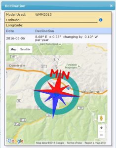
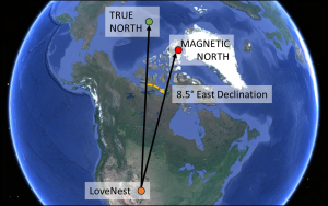
| Step 1. | Get your magnetic declination from NOAA (http://www.ngdc.noaa.gov/geomag-web/). For our location the declination on 6-May-2016 was 8.68* E +-0.35* changing by 0.10* W per year (on 6-May-2017 the declination would be 8.58* E).
For the rest of this article I’m going to use 20* East declination for a stronger visual example. More simply stated, magnetic north is 8.68* E of true north right now.
|
 |
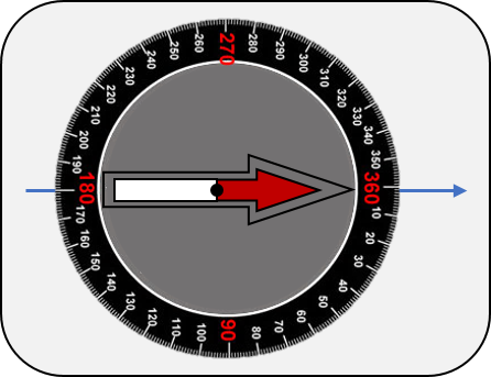
| Step 2. | Start with your compass’ north indicator align on 0*. This would be the setting if there is no declination at your location.
For our compass, the indicator is the red outline. You can ignore the actual pointing direction of the needle (solid red in the picture).
|
 |
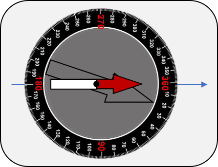
| Step 3. | Adjust the inner face of the compass to the appropriate declination. In the picture shown the declination has been set to 50* East declination. True north remains aligned on the 0* mark and the black arrow on the compass.
Now we’re ready to go sight one of the survey lines to determine if the survey is based on true or magnetic north. |
|
| PERFORM SURVEY | ||
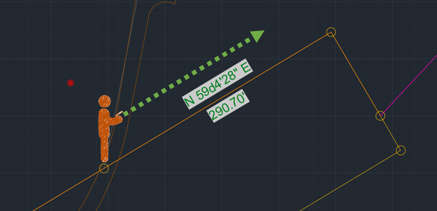
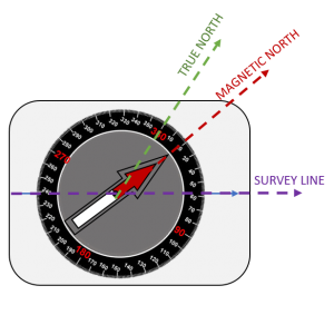
| Step 1. | Turn main dial to 59° to align the compass to the survey line we want to check | 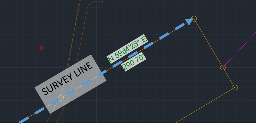 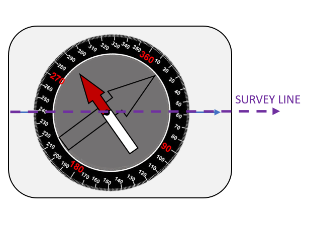 |
| Step 2. | Stand on the survey line pointing compass down the line.
|
 |
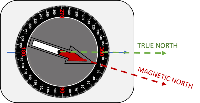
| Step 3. | If bearing was based on magnetic north – the compass would look like this. Arrow is pointing towards magnetic north and doesn’t correspond to the declinated true north.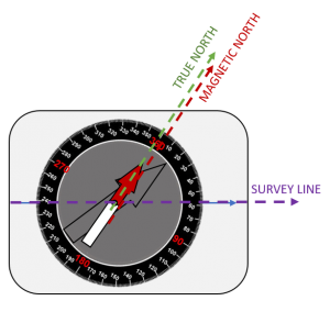 |
If bearing was based on true north – the compass would look like this. Arrow is pointing towards magnetic north and corresponds to the declinated true north.
|
| In the end we sighted the lines and determined that the bearings on our survey are based on true north. | ||
Why Not Use your Cell Phone?
Why go to all the trouble to get a manual compass, offset it for declination, and sight down a tine line when we have a handy-dandy cellphone in my pocket with a compass app? Because it lies. Really. Its really, really bad – and I’m about to tell you why.
Cellphones have a built-in sensor which detects how the phone is currently aligned in the local magnetic field. And this is actually a fairly accurate method IF you know where you are (latitude and longitude). And accurate is relative – due to sensor noise which likely limits you to +- a few degrees. But more importantly, your phone doesn’t always know where it is.
The are 3 methods your phone uses to find location: A-GPS, WiFi, and Cellular positioning. The most accurate method is A-GPS which uses the GPS satellite constellation assisted by information from local satellite towers to provide the satellite locations – which needs to be accurate to within a few feet or inches for location accuracy. But the antenna on a cell phone is really small which makes it difficult to accurately get signals which results in total system accuracy of approximately 5-8 meters. Without a cell phone tower to constantly provide updates on the location of satellites, within 2 hours the satellite location accuracy degrades and so does your location. With my current cell phone it can only guess my location on our property to a spot with a 30-60-meter radius at best. After half a day I’m lucky if it has my spot accurately within half a mile. Normally, you wouldn’t notice this in the city because your phone is constantly being assisted by cell phone towers, and your phone uses other pieces of information to narrow down your location.
Inaccuracy in your location means the sensors in your phone can’t properly interpret the magnetic fields which leads to it guessing your location. The phone will also constantly try to re-calculate position which results in it thinking its in spots very far from one another (with different magnetic fields) every few seconds, further throwing off the bearing information. Your phone’s compass map averages out these jumps to show a constant bearing, hiding the inaccuracy of the information from you.
With all the errors combined, and given the spot of our property, I wouldn’t count on my cell phone’s app to be accurate to more than 5-8 degrees. Since the magnetic declination is a little over 8* at our property, it would be impossible to determine if the bearings on our survey are true or magnetic. Probably fine to get us walking in the general direction of the freeway if we got lost, but not enough for scientific work.