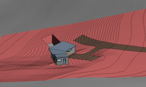
Today I finally got contour data imported into Revit and was able to create a 3D sitemap. Below is the first picture I’ve created showing the sloped hill, flattened area for driveway, and the house perched in the sky. The large hole in the ground just beyond the house represents where the septic field is going to go.
The driveway and parking area is currently sloped at about 5 degrees to follow the lay of the road and maximize water/snow shedding. The parking area runs towards the house which will cause water to run at the front door. This isn’t idea but not a lot that can be done given the topography. This end of the house will be raised above the ground a bit and we will probably put in additional topography and a french drain to redirect the water to run as we want under the house.
There’s more work to do adjusting the site map – but excited to have the first idea of how we’ll transform the ground!

